Plot twice the size of Toa Payoh reclaimed off Pulau Tekong
This is Singapore's first polder project, where low-lying land is reclaimed.
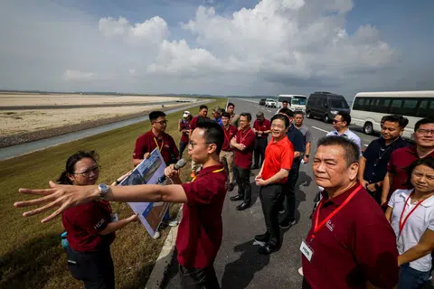
A plot of land the size of about two Toa Payoh towns has been reclaimed off Pulau Tekong, the Government announced on Sept 8.
This marks the first time that Singapore has reclaimed land below the average sea level.
The plot, measuring around 800ha, was reclaimed at the north-western tip of Pulau Tekong, Singapore's largest offshore island where many national service recruits are initiated into army life.
The reclaimed land is slated for military training purposes.
This frees up space on the mainland for other uses such as developing new homes and amenities for Singaporeans, said HDB and national water agency PUB in a joint statement.
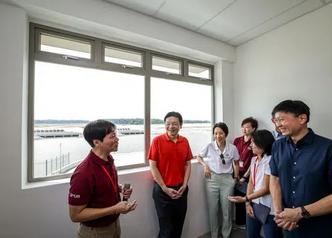
Prime Minister Lawrence Wong visited the site on Sept 8 to view the polder.
It marked a full circle for PM Wong, who had first unveiled the project in 2016 when he was Minister for National Development.
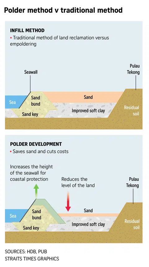
The reclamation was conducted using a method called empoldering, and main construction works for the land and its infrastructure were completed in end-2024.
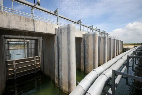
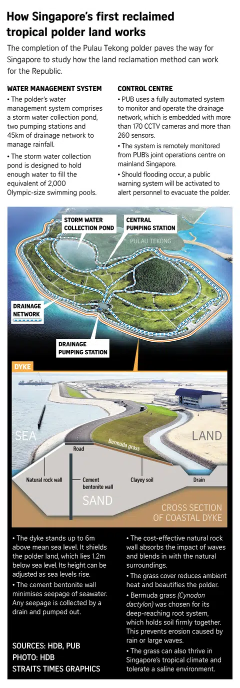
The works involved building a coastal dyke - standing 6m at its highest point - around the area to be reclaimed and draining water from it, creating a low-lying tract of land below sea level called a polder.
The Tekong polder lies about 1.2m below mean sea level.
Climate projections show that sea levels around Singapore could rise by up to 5m by 2100.
The authorities said the height of the coastal dyke can be raised if needed, to adapt to future increases in sea levels.
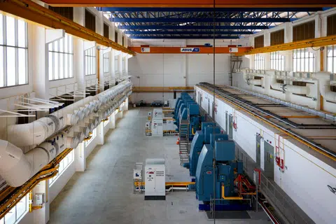
With more intense rainfall wrought by climate change, water levels in the polder are managed by a 45km-long drainage network that prevents flooding and water from stagnating.
The network comprises two pumping stations, drains and a 116ha storm water collection pond, which is designed to hold enough water to fill 2,000 Olympic-size swimming pools.
During heavy rain, the pump has the capacity to empty an Olympic-size swimming pool's worth of water in under three minutes.
This is the first time that empoldering has been used in Singapore.
Land is traditionally reclaimed by enclosing an area and dumping materials, primarily composed of sand, to create new land.
The authorities said reclaiming land through empoldering has cut the amount of sand needed by almost half, compared with the conventional method.
This has made empoldering an attractive option for the Republic, which is reclaiming more land and beefing up its coastal protection as sea levels rise.
The amount of sand used for the project was further reduced by repurposing clayey soil dredged from the construction of the polder's storm water collection pond.
This amounted to more than 10 million cubic m, or enough to fill about 4,000 Olympic-size swimming pools, the authorities said.
PUB senior principal engineer Thomas Pang said the agency has put in place a fully automated system, with over 170 CCTV cameras and more than 260 sensors installed across the polder.
These artificial eyes on the ground help to verify faults flagged by the system, and detect the water quality and water levels in the drainage network.
"This enables real-time remote operations from the polder's control centre and PUB's joint operations centre on mainland Singapore," said Mr Pang.
Responding to queries from The Straits Times, the authorities said final testing and commissioning works are still being conducted for some project infrastructure, including its telecommunication services.
Once these works are completed later in 2025, the reclamation project undertaken by HDB will be handed over to PUB and the Ministry of Defence.
In designing the coastal dyke, the Government said it worked closely with the Dutch - who have relied on empoldering for centuries to carve out new land - to adapt the technology for Singapore's context.
Although the Republic experiences milder coastal and wave conditions, rainfall is typically more intense, the agencies added.
Hence, the polder's drainage system and pumping stations was catered for Singapore's tropical climate.
On the future of empoldering in Singapore, the authorities said the experience gained from operating and maintaining the Tekong polder will guide their review of the method's viability for future land reclamation projects.
"As this is Singapore's first polder, the cost of operating and maintaining the coastal dyke and water management system can only be determined after operating it for a period of time," said HDB and PUB.
This comes as sand, a key ingredient of land reclamation, is prone to export bans.
For instance, in 2017, Cambodia permanently banned all sand exports on environmental grounds. The following year, Malaysia revived a ban on selling sea sand to other countries, citing similar reasons.
Responding to Malaysia's ban, Singapore's Ministry of National Development said then that the Republic has been encouraging its industries to reduce a reliance on sand.
Addressing the Tekong polder's environmental impacts, HDB said it had tasked an independent consultant to study the project's effects and minimise damage.
Prior to the polder's construction, NUS' Lee Kong Chian Natural History Museum and nature groups and initiatives such as WildSingapore and TeamSeaGrass were also approached for feedback on planned measures to limit environmental impact.
Taking in their feedback and the National Parks Board's input, arborists identified and transplanted endangered plant species to other places like Pulau Ubin.

HDB said surveys of nearby habitats showed that there were no significant changes to these habitats before and after construction of the land reclamation project.
They cited how similar species of flora and fauna such as sea grapes, sea stars and sea sponges continue to be observed in the area.
Singapore uses land reclamation as a tool in its arsenal against climate change.
Almost a third of the country rests just 5m above sea level, making these areas vulnerable to being flooded by rising sea levels in 2100, when combined with extreme events such as high tides and storm surges.
At Budget 2025, it was announced that Singapore's Coastal and Flood Protection Fund - to safeguard the country from rising seas and floods - will receive a $5 billion.
Currently, there are four ongoing site-specific studies, with plans to commence two new studies at Singapore's south-west coast and Sentosa by 2026.
Ang Qing for The Straits Times